Posts

Showing posts from September, 2019

Last Day

Image
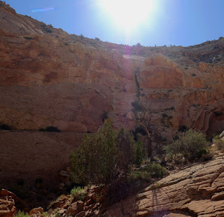
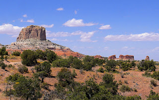
This final day of our trip (we head back home beginning Monday), we finished the Scenic Drive out to Capitol Gorge, walked the gorge, and then returned to park headquarters to pick fruit in the orchards and eat more pie at the Gifford House. An interesting note on this area, the first American settlers here were a band of Mormons who, apparently, sought to put some distance between themselves and the formal church in Salt Lake.  They found an arable little valley irrigated by the Fremont River,where the park headquarters now are, and began raising tree fruit. When the lands came to the National Park Service in the 1920s they decided to preserve the orchards, so today you can pick fruit here, and we did, about 4 ½ pounds of apples and pears. Were we to do this trip again (and we might) I would want to have a four wheel drive vehicle and the ability to walk more than the three miles we did today. Only then could we more fully explore this wilderness wonderland.

Capitol Reef

Image
Saturday saw us making the brief journey from Escalante National Monument to Capitol Reef National Park. We were totally unfamiliar with this site until we began planning the trip and Sharon's brother, Larry, said we had to see it. He was right. As you can see, the scenery in both areas is spectacular. We reached Capitol Reef at mid-day and stopped off at a surprisingly crowded visitor center. There we got maps and decided to visit Gifford House, known for its homemade fruit pies which were remarkably good. Sharon had cherry, I had peach. After “lunch” we drove out along the paved portion of the ten mile Scenic Drive, the backbone, so to speak, of Capitol Reef, and on the way back took a couple of short walks out to Panorama Point and along the Sunset Point Trail.  Rosa points the way The plan for Sunday was to walk the slightly longer Capitol Gorge Trail.

The Devil’s Backbone

Image
We spent our only full day, Friday the 13 th , here on a couple of “trails,” backroads, really. In the morning we covered about 45 miles over the Devil’s Backbone, a graded but unpaved road, and then in the afternoon we traversed about an equal distance on The Burr Trail, which was paved. A word of advice, anyone wanting to see all this place has to offer should bring at least an SUV, and the folks who seemed to have the most fun were in  ATVs. And you should allow more like three days, depending on how much hiking you are up for. But we managed. The Devil’s Backbone is presented no real difficulties for either us or Rocinante and took us through forests of aspen and pine and some spectacular canyons.  The Burr Trail, too, was spectacular, featuring more gorgeous red sandstone and those hoodoos that they do so well, but we were unable to find the unmarked trail leading to a slot canyon and some petroglyphs, still we found our own minor slot canyon and

To the Staircase

Image
Today’s journey took us from Page, Arizona and Lake Powell across southern Utah to Grand Staircase Escalante National Monument.  Unlike the previous day, it was not an arduous drive and as we traversed mountain passes, plateaus, and canyons, the scenery grew increasingly spectacular until we hit Red Rock Canyon where we got out and walked among these rock formations. Some of the most vertically spectacular of these are called hoodoos. Interestingly, the camera did not, could not, I guess, replicate the intensity of the colors we saw. But these images get close. Dusty, but thus far undented, Rocinante awaits The final image is the hills outside our hotel window at sunset. We will celebrate Friday the 13 th  by going off-road, which is really the only way to see this place, in the coupe. What could go wrong?

An Interesting Drive

Image
Wednesday, September 11 took us from the Zuni Pueblo to Page, Arizona, about a 300 mile drive, but with an unanticipated twist, a twelve mile unpaved section of Indian Route 59 that I was not sure we were going to make it across.  Don't let the looks fool you, yes, this road was graded, but it was also washboarded and silted, yeehaw!! But we did, although both the car and we were covered in red dust by the time we arrived at Lake Powell outside of Page. In the morning I will pull the air filter and give it a curbside cleaning. Notwithstanding that portion, it was a very fast (don’t ask) drive, and we got into Page in time to take a tour of the Glen Canyon Dam. We’ve been through here before, but never took the time to do the tour. The shape of the dam is designed to divert water pressure from the center to the canyon sides The bridge was a project of its own Lake Powell, looking from the dam east Our tour guide was Page from Page, as she describ